The purpose of this page is to describe in detail the various prospects that exist for photography on the Settle to Carlise line between the Eden Gorge at Armathwaite and Settle itself. These comprise a personal selection, there may be others I have yet to discover that I will add in due course. The locations are listed in geographical order from south to north.
Ribblesdale - Stainforth
Immediately north of Settle, the line keeps close to the east side of the valley here less than 500 metres wide. The rock cuttings are 10-15 metres deep and the view of the line is limited.
A footpath from Langcliffe to Stainforth passes through the former lime works and associated sidings, built in the 1870s to take advantage of the new railway. The industrial archeology here is worth an excursion in its own right. The Hoffman kiln is a huge structure, complete except for the upper level. It is possible to go inside, but a proper torch is necessary to examine the detail. Trails are clearly marked, and there are information boards.
At the site of the sidings, there use to be a path along the lineside, separated from the Up cess by the old type of low wire railway fence. This was a reasonable spot for taking photographs, with a good view in both directions. However, the sidings have recently been redeveloped into office accomodation, and a permanent welded wire mesh fence, two metres high, has been erected north from bridge 17 to the Hoffman kiln. This new fence, which is also set back two to three metres, obstructs photography.
Between Stainforth and Helwith Bridge, the line crosses the Ribble twice in the space of 300 metres on two similar, skewed viaducts. Unfortunately, the first of these, Sheriff Brow Viaduct, is completely surrounded by large trees and inaccessible by any public right of way. The second, known as Little Viaduct, can be seen from main road, where there is a convenient lay-by. However, the view is restricted, as illustrated in the photograph to the right. Once again, there is no public access to any land from which a good composition may be had.
Ribblesdale - Helwith Bridge
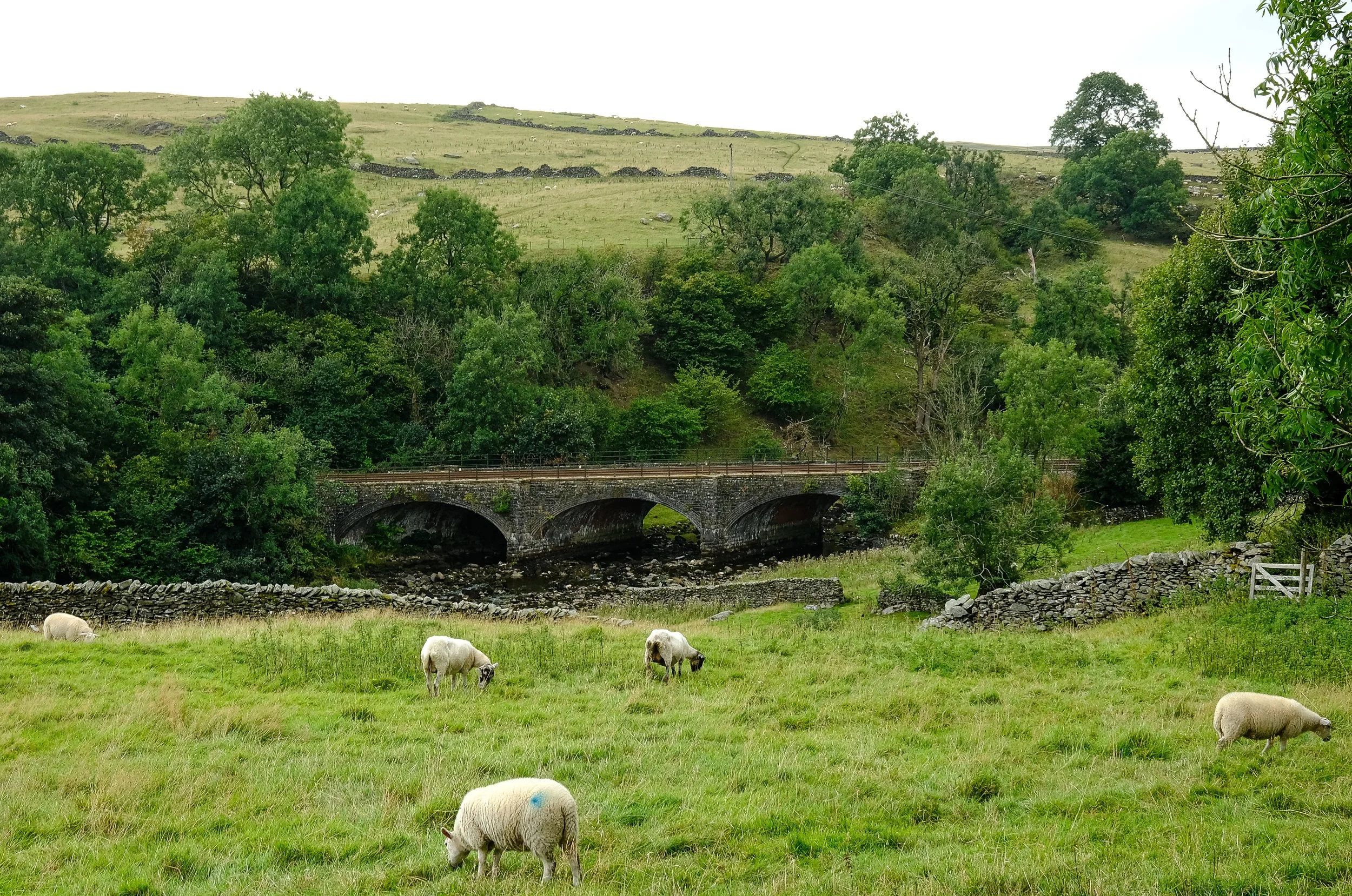
At Helwith Bridge there is a small free car park opposite the houses. A footpath leads along the entrance road to the quarry, from which can be seen the third viaduct over the Ribble. This is a simple four arch struture shown right. The green sign indicates no public right of way.
The path forks to pass under a modern bridge with the line on an embankment. After 100 metres where a footbridge crosses the river, there is a footpath through the field opposite. This leads to an at-grade pedestrian crossing over the line, from where there are possibilities, particularly to the south because there is a significant change of gradient about 100 metres distant.
Some people position themselves by the bridge or just along the quarry access road, which provides a partial view of the viaduct.
Following the quarry entrance road and then turning right along a track (public footpath) brings one to a crossing over the quarry railhead (use the footbridge not the at-grade track). Continue along the path towards the large Cragg Hill Farm (a huge camp site in summer), and it soon descends through a pasture towards the railway at the point where the railhead joins the main line. There are a number of positions in this area with a good view of the line. It is possible to stand above trackbed level, but at the loss of 50 metres in distance; furthermore, there is a lot of clutter in the form of a wooden fence, several lineside cabinets, and a 33kV pole with a large transformer that all interfere with the composition. Better to take up a position behind the wooden fence, my preference being just by the Stop sign and catch points on the railhead, as illustrated to the right.


Selside Cottages
At SD788746 there is a pull-in next to the Pennine Bridleway that heads off east across a pasture towards the railway. As the bridleway approaches the line there are several compositions to be had, north and south bound on the west side. The bridleway passes under the line and the land on the east side is below grade. Follow the bridleway towards High Birkwith for a good view of the Ribblesdale drumlin field, evidently why the railway could not have been built on the east side of the valley. There is a lovely 6 mile circular walk back to the parking spot via Hornsey Hill, Selside and the track that leads up to Alum Pot. If you want to visit the caves you are required to pay £1 at Selside Farm, because the path is across private land. To the right is the southbound shot from just off the bridleway.

Or there is a composition northbound with Pen-y-ghent in the background. This is one of many possibilities at this location.

Ribblehead Viaduct

Along with Aisgill (see below) the most popular location on the line outside the stations. The principal disadvantage with this location is that even on a dull, wet, midweek morning there will always be people in the shot, casual walkers who realise what is going on and stop where they like.
The best location is up on the hillock about 50 metres to the right off the trail up to Whernside via Blea Moor Tunnel south portal. There is a very good view south across the viaduct, and the approach of the northbound train can be seen from a long way off. Just after the locomotive clears the parapet everything is visible, but the tops of the trees on the abutment will spoil the end result if you leave it a fraction of a second too late.
There is a possible southbound shot here, but it is inferior to other locations. Better is the view from the lay-by on the Ingleton - Ribblehead road, 300 metres south of the station.
Finally, one ought to note there is no 4G signal at Ribblehead, so one is unable to access realtimetrains for live updates.
Ribblehead Viaduct crosses Batty Moss, and was initially known as Batty Moss Viaduct. This 400 metre wide bowl is the divide between the Ribble and Lune catchments. When the railway arrived here it was a peat bog 8 metres deep. At least of equal interest to the viaduct are the remains of structures relating to the construction of the railway. Nine residential settlements existed in this area, with names such as ‘Sebastopol’, ‘Belgravia’ and ‘Batty Wife Hole’, all of which had a their own public buildings. There was a brickworks, lime kilns, quarries and an embanked semicircular tramway leading up towards Blea Moor. For those who are interested, I suggest the publications highlighted in the section on Further Reading, particularly the conservation appraisal.
Blea Moor Tunnel North Portal

The location for a classic northbound shot. It is possible to park in the Network Rail access point by the lineside at the north end of Dent Viaduct, although those with low clearance vehicles should take care at the entrance. (Alternative parking is available under the viaduct, which involves a walk back up the hill.) There is a small green sign that says ‘private land’, but this seems to be widely ignored, and from the far corner a distinct, short path leads to a spot 200 yards or so from the Portal. The line curves away from the photographer so that a well timed shot will encompass the loco with valve gear and nameplate visible, also a good part of the rake of coaches behind. Unfortunately, the hillside above the portal is somewhat unattractive, but that is really a minor criticism.
Update: As of November 2024, the very well used minor road from Newby Head down to Dent Head Viaduct and through to Cowgill (Dent Station) was closed just west of the viaduct due to a landslip. It could be closed for a long time, two years maybe according to a local resident, certainly it was still closed at the end of March 2025.
The is a public footpath crossing Blea Moor from the north portal. The track links the old spoil heaps and the 150 metres deep air shafts. On the way up to the portal are crude stone structures believed to be associated with the Tunnel Huts construction settlement. Also visible is the 2 kilometre tramway used to move coal up to fixed steam engines employed for excavation purposes.

Dent Head Viaduct
A good location for a southbound shot. Parking is the same for Blea Moor Tunnel North Portal. You will always see a few people standing along the road above the viaduct. There is a long approach warning as smoke is visible from Dent Station. You don’t necessarily need a telephoto from here to get a good result. Any camera with a good sensor and optics will produce something decent that can be worked with.

In my opinion the best of all locations. It is possible to gain a little height above the track, which is at-grade as it joins the north end of the viaduct. There is a small depression between the viewpoint and the lineside, where the pasture boundary wall is located. Wait until the locomotive has crossed the viaduct and cleared the parapet before pressing the shutter. Everything is then visible, with a long rake of coaches back across the structure. The photograph on the right is taken from what I consider to be the prime spot on the north-east side, although some prefer to gain more height, which is possible.
Accessing Arten Gill is not easy, which tends to put off those unwilling to make the effort. Car parking in upper Dentdale is scarce, and there is a walk of about 500 metres up from the road, with a total climb of about 50 metres to the viewpoint. Take the bridleway by Stonehouse Farm (no parking here), and just after passing under the viaduct there is a gate to the left leading into into the pasture. This is just inside the National Park boundary, so is open access.
Arten Gill Viaduct northbound
Arten Gill Viaduct - Southbound
A southbound photograph is possible at Arten Gill, but requires considerable effort. The only access now is from the gate on the right side of the bridleway after one passes under the viaduct. It is necessary to descend to Arten Gill and cross it, then climb to the view point on the south side. Getting down to the Gill is relatively easy, and so is crossing it, (unless there has been recent heavy rain, in which case you will need wellingtons and a stout stick for support). The climb up on the other side is steep, though easier than it looks from the bridleway. There is a low wire stock fence to be surmounted, but this does not presently have barbed wire on top. Don’t try walking up from the farm at the bottom of the Gill on the west side of the line. I am told the landowner chases people off. Keep to the east side which is in the National Park and is therefore open access land.
One is rewarded with a position very close to the lineside, almost too close for still photography, and a great composition with Dentdale, Dent Station, Rise Hill and Baugh Fell in the background. Alternatively, there is a position that gives a complete view of the viaduct to its full depth, although ones distance to the subject increases by around 30 metres.


Green Bank, Great Knoutberry Hill
The Pennine Bridleway is more of a viewpoint than a place to take detailed photographs, unless one has equipment that includes a super-telephoto lens and tripod, because it is always breezy, at a height of over 500 metres. Green Bank is accessible either from Arten Gill or from the ‘Coal Road’ above Dent Station.
From Green Bank (marked only on the larger OS Map) one has a view all the way down Dentdale. Almost the entire length of the line between Dent Station and Dent Head Viaduct is visible, though at its closest point the track is 600 metres distant. However, this is within the National Park, so one may walk down across the open fell to get closer to the line. The best point of departure is at SD7736 87113 between two streams marked on the OS map. The ground is quite firm and there is even a discernable path for part of the way. At the line side there is an unrestricted view in both directions from several little knolls. One can see all the way from Dent Station to the north portal of Blea Moor Tunnel. The climb back involves a rise of 570 feet in half a mile. Bottom right illustrates the view southbound, mid afternoon in summer.
As a detour, the ascent of Great Knoutberry Hill (pronounced ‘nutberry’) repays the further 160 metres climb, with a 360 degree panorama taking in all the major peaks in the Western Dales. There is a shelter with stone seats at the summit where lunch may be taken.
Dent Station & Rise Hill
I have read that the road bridge at Dent Station is a classic location, and I understand why this may have been so. The old snow fences are particularly attractive in early evening light. However, the compostion has been spoiled by the erection of a GSM-R tower in the Up cess just south of the station. This eyesore ruins any composition.
The line from Dent Station to the mis-named Rise Hill Tunnel can be viewed from the bridleway that links Dentdale with Garsdale. The route starts at Dockra Bridge near Cow Gill by a small chapel. The bridleway is easy walking, steep at first, but soon levelling out. After about 2 kilometres, Arten Gill and Dent Head Viaducts come into view, and then Dent Station. The line north of Dent Station cuts through Helmsike Hill and then follows the contour on the level for 600 metres before entering Rise Hill Tunnel South Portal, of which there is only a glimpse from the bridleway. The tunnel is mis-named because it does not pass under Rise Hill, it lies under the saddle between Lousegill Wold and Little Snaizwold Fell. Rise Hill top is three kilometres to the west.
The best composition (primarily a northbound shot) is to be had just before the bridleway turns sharp left to descend into Garsdale, about 2.5 kilometres from the Dentdale road. There are great views to Whernside, Gragareth, Great Knoutberry, Wold Fell and Blea Moor. At one point the wall to the left of the bridleway has partially collapsed forming a convenient seat. This is a great location for quiet contemplation, silent but for the sound of Cowgill Beck passing through the deep culvert under the railway.
NB: at the top, there is no 4G signal, and the land to the right of the bridleway is not open access; that said, the wire fence is surmountable where an old feed sack has been wound round the barbed wire top strand and a couple of large stones have been placed conveniently.

Garsdale - High Scale
From the cottages adjacent to Garsdale Station there is a footpath through a sheep pasture that reaches a farm overbridge after 400 metres or so. From this bridge there are decent compostions in either direction. The southbound is perhaps the better of the two, but requires late afternoon or evening sun. The photograph opposite was taken at midday.

Garsdale Station
Garsdale is the only station on the line that I would consider as a location for still photography. The Station itself is most attractive, with its freshly painted signal box and semaphore signalling. Southbound trains approach on a curve, and there is a good shot from the north end of either platform.
There is plenty of parking. The overflow car park is divided from the Up cess by nothing more than a low fence. There is a good view of Northbound trains from here.
There are a considerable number of structures worthy of interest, some of which are still in use, such as the terrace of workers cottages.
Garsdale was originally known as Hawes Junction station, and the remains of the trackbed curving away to the east can be seen from Dandry Mire.

Moorcroft (Dandry Mire) Viaduct
When one walks under the Moorcroft Viaduct it is difficult to believe that 200,000 cubic metres of spoil were dumped in such a small area and sank into the peat bog. But if one looks carefully at the piers one can see fractured tell-tales and the cracks in the stone blocks that suggest the structure is slowly sinking. It is said that when the proposed embankment across Dandry Mire was abandoned in favour of a viaduct, they had to cut a trench down to the bedrock to found the eleven piers.
There is a possible northbound photograph from the Pennine Bridleway at the southern end (see right). There is also a possible southbound shot from the bridleway just before it begins to descend to go under the viaduct.


The best view is to be had from the disused, embanked trackbed of the Hawes branch, which can be accessed from the bridleway. There is a easily discernible path heading off towards the south abutment where an old gate allows acces to the embankment. This is slightly lower than trackbed level on the viaduct.
Even with the 23mm lens on my X100V it is not possible to get a shot of the entire viaduct, as there is a substatial fence that prevents one from walking back towards the station. But from the trackbed there are several good compositions in both directions. Pictured right is the view north towards the Moorcroft Tunnel.
South Lunds
One of the lesser-known locations, just north of Dandry Mire on the other side of the short Moorcock Tunnel. The viaduct is formed of five arches and is visible from the main road up Mallerstang towards Aisgill. The best still photographs are to be obtained from the west side of the railway where there is a small hillock known as Cock Lakes, about 10 metres above trackbed level.
There is no parking on the road, so access is best obtained by parking at Garsdale Station and walking over the moor using the footpath opposite the houses shown on the map as East Mud Becks. After the first stile, the path becomes a quad track. Where the track clearly turns left and goes uphill, make sure to leave it and follow the distinct path straight ahead. In total it is a brisk 10 to 15 minute walk. The path looks like it could be boggy, but I have never found it so, even after a few days of rain.
When the path starts to descend, follow the 350 metre countour around the hill and there is an excellent view of the viaduct, with little in the way of lineside obstructions, and a lovely prospect down towards Hawes, that makes a good backdrop. I have seen old shots taken south of the viaduct from a position closer to the tunnel entrance. I have not been round the hill that far, but the ground is good and it is open access, so it ought to be doable. I propose to investigate further at some future time.
The distinctive 1930s plate girder bridge at Grisedale Crossing has a view to the south of the tunnel portal with its curious S bend approach. The plan was to cut through Cock Lakes, but the underlying ground was found to be prone to slippage, so a tunnel was preferred. Note the design of the portal with its shallow cutting and splayed wing walls designed to cope with the bad ground.


Shotlock Tunnel
Shotlock Tunnel is one of the shortest on the line, and like the nearby Moorcock Tunnel it was constructed because the overlaid boulder clay was was judged to be unsuitable for a cutting.
There is a small lay-by just south of the southern portal. The railway can be seen from here, but the composition is unsatisfactory. A short walk north along the road brings one to a footpath off to the left over the tunnel, which then turns right to follow the line for a couple of hundred metres. After passing through a gate, the footpath heads off to the left, but a narrow path can be seen to go straight ahead, which leads very shortly to a hillock from where there is a clear view of the north portal and through the tunnel. A decent northbound shot.
The indistinct path continues over the hillock to another position where there is a reasonable composition for southbound trains, with Wild Boar Fell in the background.


Ling Hills to Hellgill Force and Aisgill Summit
About 500 metres north of Shotlock Tunnel one reaches Shaw Paddock where the road passes under a bridge and moves to the west side of the line. Immediately after the bridge on the east side there is a lay-by with space for several vehicles. From here one can walk another 500 metres north along the road to White Birch Cottage where a public footpath leads across a pasture to an at-grade pedestrian crossing. There are hillocks in the pasture from where a photograph is possible of a southbound train exiting a shallow cutting onto open line.
The public right of way continues over wet(ish) but not grossly boggy ground to How Beck Bridge where one can pick up the byway that leads across the watershed. (There is no discernable path, use compass bearing 110 until you reach the top of the hillock when the bridge comes into view) This is a worthwhile walk because from the highest point (Jingling Hole) one can understand the choice of the route north of Garsdale. Crooked Rigg is evidently the lowest section of the watershed. One also passes over a small, rustic old bridge (Green Bridge) below which there is a little stream, actually it is the River Ure, and therefore the source of the River Humber.
From How Beck Bridge the byway takes one to Hell Gill Bridge where the incipient River Eden (known here as Hell Gill) is crossed, and a public footpath leads back down the other side along the Gill. The Gill has cut through the limestone bedrock creating a noteworthy pattern of erosion. The path (actually the drive to a house) continues to a sharp left turn where the distinctive sound of a waterfall is heard. This is Hellgill Force where the river drops ten metres into a deep pool. This is definitely worth a look and a photograph. There is a clear path to the viewpoint. From this path it is a short walk across rough but dry ground to the railway boundary wall with a good view of the line. The surveyors avoided having to bridge the River Ure on the south side of the watershed, but the River Eden/Hell Gill strayed too far west into the path of the line. The railway could not go any further west in the valley, so the builders of the line ‘stole’ the river bed, and the massive, buttressed embankment retaining wall is plainly visible (see right).
The public footpath continues back to the road at Aisgill Moor Cottages via a three arch bridge over a cutting. There is a new Network Rail access point on the west side of the bridge which rather defies description, I have never seen one like it before. South of this bridge is the summit of the line where Crooked Rigg and the 360 metre contour are crossed. Lie-by sidings were built as a refuge for slower trains and there was a signal box; all have been removed and vegetation has been allowed to grow unchecked.


Aisgill - Cotegill Bridge
The road re-crosses the railway at Cotegill Bridge, which location most people refer to erroneously as ‘Aisgill’. Ais Gill is in fact 400 metres to the north by Aisgill Farm where there is a viaduct. Cotegill is understandably popular with railway enthusiasts and with the general public if only because there is parking for a dozen or more vehicles on the main road.
The northbound shot (looking south towards the summit) is best from the main lay-by adjacent to the road bridge, and there is plenty of room here for everyone. However, some people like to cross the area of rough ground between the road and the railway to stand by the lineside, which rather spoils the composition.


The southbound shot really has to be taken from the west corner of the north parapet of the bridge. You can expect there to be competition for this place.
Aisgill Viaduct
To access Aisgill Viaduct, park at Cotegill Bridge and walk 500 metres down the hill along the main road to Aisgill Farm where a gate on the left side leads to a track through open access land underneath the viaduct. Here there are several places on the hill above the track where there is a composition in either direction.
Mallerstang Common makes a great background to the southbound shot if the light is right.
The northbound shot requires the sun to be on the west side of the line. The photograph on the right was taken at 10.30am in September, and the result is evidently unsatisfactory.


Mallerstang - Hazelgill
This is not the best location by any means, but there are possibilities in both directions. I discovered it on a walk up to Wild Boar Fell. The bridleway leaves the valley road and climbs 50 metres up to a bridge over the line. On the left of the path as it winds up the hill there is a sheep pasture with a few hillocks. At this point one is about 5-10 metres above the trackbed.
One needs to be on the alert because there is almost no approach warning, apart from sound. Also, there is a bit of clutter in the foreground; it’s not posible to eliminate the wall and fence from northbound shots. Heading north, the train will pass on the downgrade at around 50mph, so a high shutter speed is a priority. Around the zenith, sunlight will reflect strongly from the top of the boiler, and this has to be minimised or the shot is ruined. The photograph on the right of Leander heading north illustrates how everything can go wrong!
Parking on the road at this point is scarce. There is a small lay-by at The Thrang and a space for one car at Boggle Green. One could park at Pendragon Castle from where there is an easily followed public footpath via Shoregill and Deep Gill. It was in a pasture near the latter in late June 2022 that I saw two oystercatchers with their young scampering about in the grass at least 200 metres from the River Eden. Subsequently, I learned that oystercatchers were first observed in Mallerstang sometime during the 1920s.
It is a relatively short, but in places steep walk from Hazelgill to Wild Boar Fell, but one that rewards the effort, even if only as far as the saddle that has the unusual name of High Dolphinstry. The bridleway, initially stony, becomes grassy and crosses good ground, but one must watch out for mountain bikers.
Pendragon Castle is free to enter and there is a newly constructed parking area on the main road. Wild Boar Fell is visible way up in the distance between the two trees.


Mallerstang - Tommy Road
A good location for shots both northbound and southbound. It is reached using the minor road off the A683 south of Kirkby Stephen at NY757037. Or from the minor road up past Pendragon Castle. There is off-road hardstanding by the cattle grid at NY762038. Walk down the hill and take the bridleway to the left as the road bends to the right. (A lot of people park by the entrance to the bridleway, but I would not recommend it if you drive a vehicle with low ground clearance) After about 300 metres the bridleway divides. The best shots are to be had by taking the right fork from which two hillocks can be accessed with a clear view of the track. There is a small bridge where the bridleway passes underneath the railway that adds foreground interest.
One can also continue along the left brideway between the two walls, which after 400 metres or so meets the lineside at grade, a stone wall dividing it from the Down cess, before rising to cross the trackbed on a bridge. This area offers some photographic possibilities also, even on a dull, brooding day.
The bridleway down under the line brings one to to the remains of Lammerside Castle, a C14 pele tower. There is a circular walk from here to Wharton Hall, another C14 tower house. Parts are visible from the bridleway, but much has been obscured by modern buildings, and there is no public access.
Smardale and Crosby Garrett
Smardale Viaduct is the tallest of the structures on the Settle to Carlisle Line, though it comprises only twelve arches. Unfortunately, there is no public access to any ground position from which there is a decent composition of the whole viaduct. At the east (Smardale) end, there is a footpath up to Smardale Fell from which there is a limited view of the viaduct approach, sometimes referred to as the ‘Smardale Curve’. At the west (Crosby Garrett) end, a footpath crosses several pastures on the lower slopes of Nettle Hill/Beacon Hill. By straying several hundred metres off the right of way it would be possible to obtain a reasonably close view of the whole viaduct. However, this might involve conflict with the landowner. In early August 2022, one of the pastures contained thirty rather exitable and inquisitive bullocks. It occurred to me they may have been put there deliberately to encourage people to stick to the path!

Crosby Garrett viaduct is a smaller skewed structure. Like Smardale, it is difficult to obtain a satisfactory photograph from any position. The village lies on the north side, and the raised land to the south does not approach close enough. Like Smardale, there are several mature trees that impede the view.
The only half-decent prospect is from close to the public footpath heading south, illustrated right. There are some grassed platforms here that look like golf tees, and there is at least one stone tee marker. On Google Earth there appear to be ghostly remains of fairways. However, I can find no mention anywhere of there ever being a course here.
Crosby Garrett station was built in the cutting to the east of the village, and was completely dismantled long ago; not a trace remains. Mature trees have been allowed to grow in the cutting. The cast iron lattice pedestrian bridge is unusual and worth a look. A photograph of northbound traffic could be had from this bridge as the line curves away towards the viaduct.
Underneath the viaduct in the verge there have been erected three old stoops as a memorial to thirteen children, five women and twelve men who died during the construction in this area. Presumably, several of these people died of smallpox, which was rife in the construction settlements.

Little Salkeld and Long Meg
A farm track (public footpath) leads north from Little Salkend very close to the lineside. Here are a number of locations where decent compositions may be had before the line enters a wooded cutting. The farm track can be followed until it becomes a path and skirts round a sub-station past a Network Rail access point on the site of Long Meg Sidings. Two hundred metres or so past the substation there is a short, steep path down to a rather unstable stile that gives access to pasture adjacent to the River Eden. From here there is a view up to the Eden Lacy or ‘Long Meg’ Viaduct. As at late August 2022, major work is taking place around the structure, there are several 13 tonne excavators parked underneath, and a number of metal site containers, all of which rather spoil the composition.
Having returned from the pasture to the main path, there is a circular walk (total about 7km) continuing north along the river bank to Daleraven Bridge, right along a minor road for 400 metres, and then back to Little Salkend down a permissive path, which passes through a notable neolithic stone circle known as Long Meg and her Daughters.

Armathwaite to Lazonby
South of Armathwaite there are very few places where the track can be accessed. The problem presented by the Eden Gorge was solved by deep cutting and tunneling to the west of the river through heavily wooded country. The line exits the cut just south of Lazonby Manor, where from Fiddlers Lane there are superb views down the valley. There is a small parking area adjacent to the sandstone overbridge from where there is a prospect north of a rock cutting, with the remains of a platelayer’s hut visible. From the other side of the bridge, there is a good view of northbound trains.
South of Lazonby there is a short tunnel followed by a high, wooded embankment obscuring everything until Eden Lacy Viaduct.